2018年4月30日 星期一
Changes At NASA HQ
FYI all of the Trump political appointees at @NASA HQ now answer directly to #NASA CFO @JeffDeWitAZ pic.twitter.com/BzVgxa3vAt
— NASA Watch (@NASAWatch) April 30, 2018
from NASA Watch https://ift.tt/2HEhqkz
via IFTTT
Twin Spacecraft to Weigh in on Earth's Changing Water
April 30, 2018
from NASA https://ift.tt/2jj0v8j
via IFTTT
Ganymede: A Moon Like No Other

Boeing's Misleading Anti-SpaceX Pro-SLS Facebook Ad Campaign


This ad is currently running on Facebook. According to the coding embedded in the link it is "campaign=acquisition_newsletter_tier-two-space-race-b" and I am an "enthusiast". When you go to the link it sends you to this page at watchusfly.com (registered by Boeing in 2016) which says "America is in a modern-day space race, and Boeing is leading the charge by building the spacecraft that will keep us in the lead. Boeing's Space Launch System is the world's largest and most powerful rocket. It is the foundation for America's plan to send humans to Mars. Boeing's Starliner is a re-usable capsule that will soon be the method NASA uses to send astronauts into space." But when you go to this page for more information it says "NASA's Space Launch System provides a critical heavy-lift capability, powering people and cargo beyond our moon and into deep space."
For starters NASA is building the SLS. Boeing - along with Lockheed Martin, Aerojet, Orbital ATK, and Airbus are building the pieces. One page says it is Boeing's SLS. The other says it is NASA's. Which is it? And yes, Starliner will be sending human crews into space but it is not "the method NASA uses to send astronauts into space." It is one of the methods - SpaceX is another method.
If you click "contact us" you get a page with lots of links. Go to About us which says "WHY JOIN WATCH U.S. FLY? In today's global environment, our policymakers in Washington, D.C. and around the country need to be aware of how their decisions will affect the millions of Americans who directly or indirectly depend on our aerospace and manufacturing sectors. The Watch U.S. Fly community helps to bridge the gap and connect the personal stories of our advocates around the country to the policies, legislation and decisions that politicians are debating. And our voices make a difference." OK, so this is actually a page that is trying to get people to lobby Congress. They don't tell you that when you first visit, do they?
Then you can go to Take Action where they suggest that you can take action on "Support Boeing T-X Today." So this is bait and switch. They tease space people in and then try to get them to support something Boeing wants Congress to buy to train fighter pilots.
And then if you go to the Blog link you see things like "NASA: SPACEX FALCON HEAVY IS 'TOO SMALL' FOR DEEP SPACE EXPLORATION" which says "However, the Falcon Heavy failed to impress the spaceflight department at NASA. Bill Gerstenmaier, the head of spaceflight at NASA, said the Falcon Heavy is "too small" for NASA's needs." So this is not really a website that supports space flight as much as it is one that only supports SLS and Boeing defense products and dumps on SpaceX overtly using statements by NASA managers in those comments. If you sign up for the Boeing newsletter with Facebook "Watch U.S. Fly will receive: your public profile and email address." So Boeing will know a lot about you that you may not want them to know.
The bottom of the page says "Watch U.S. Fly is a community of Americans that believes that America should lead the world in technological advancements. We realize that in order to maintain our edge, American aerospace must have the support of policymakers so they can continue to chart the future." and then "Copyright © 2018 Boeing. All Rights Reserved." Who is "we"? Who is this "community"?
People going to the page that this Boeing Facebook advertisement is slyly sending them to are getting misleading - and overtly incorrect and biased information. Contrary to the teaser line that this is all about "the path to Mars" (oops we're gong to the Moon now) using imagery that overtly features the NASA logo, Boeing wants you to think about Boeing - and only Boeing.
from NASA Watch https://ift.tt/2jfkswR
via IFTTT
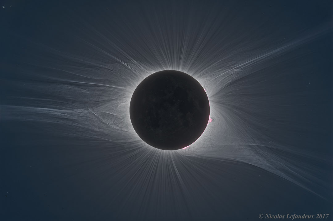
Total Solar Eclipse Corona in HDF
2018年4月29日 星期日
New Shepard Goes To Space - And Back - Again
Blue Origin's New Shepard Goes To Space - And Back - Again (with video)
"New Shepard flew again for the eighth time on April 29, 2018, from Blue Origin's West Texas Launch Site. Known as Mission 8 (M8), the mission featured a reflight of the vehicle flown on Mission 7. The Crew Capsule reached an apogee of 351,000 feet (66 miles, 107 kilometers) - the altitude we've been targeting for operations. For the second time, Blue Origin's test dummy "Mannequin Skywalker" flew to space conducting astronaut telemetry and science studies. The flight also carried research payloads for NASA, the German Aerospace Center (DLR), and commercial customers."
from NASA Watch https://ift.tt/2HHIFXv
via IFTTT
2018年4月28日 星期六
Is @JimBridenstine Actually The Voice of Jim Bridenstine?

The way that @JimBridenstine speaks is not the way that Jim Bridenstine actually speaks. Here in Washington many of us know how Bridenstine talks. Someone is running this account for him. That is not a big surprise since many important people have their public relations organization run their social media accounts. As such, you would expect that NASA Public Affairs would be running this account. But that is not what is happening. NASA PAO is not running @JimBridenstine. In fact, last week, multiple sources in meetings at NASA HQ recounted that NASA's AA for Public Affairs Jen Rae Wang did not know who was running @JimBridenstine and was trying to find out who was.
As is the case with the President's Twitter account, when a social media account purporting to be the official voice of a government official says something, you would rightfully expect that what is being said by that account is indeed being said by the person in whose name the Twitter account speaks - right? Right now that is not exactly certain.
As was first reported on NASA Watch on the morning of 26 April, NASA HQ has decided to cancel the Resource Prospector mission. That decision was made on 23 April while Bridenstine was being shown where the coffee machine is. In the evening of 26 April, hours after that news had already spread across NASA @JimBridenstine tweeted "Great 3rd day on the job with the @NASA family. Excited to get to work on our plan to sustainably return America to the surface of the Moon starting with an aggressive robotic program." It was somewhat odd to see the (apparently) official Twitter account of the NASA Administrator talk about an "aggressive robotic program" on the Moon hours after the news of a stealthy decision within the agency he now leads to cancel a lunar robotic mission leaked out.
The next day, on 27 April at 5:11 pm, @JimBridenstine issued another official tweet "We're committed to lunar exploration @NASA. Resource Prospector instruments will go forward in an expanded lunar surface campaign. More landers. More science. More exploration. More prospectors. More commercial partners. Ad astra!". Yet sources I have spoken with at NASA HEOMD and SMD are not exactly certain where the wording for that tweet came from either. This just does not sound like Jim Bridenstine - and NASA PAO is not the source.
Then, by coincidence, at 8:33 pm on 27 April, the long formant account tweeted "NASA Administrator Jim Bridenstine is off to a fast start toward implementing the President' Moon program. He is going to combine NASA instrumentation with commercial Moon landers to accelerate the Moon research program and land on several more sites than envisioned before."
And it is probably just a coincidence that an op ed by Walker's compatriot in space commerce advocacy, Newt Gingrich, appeared online on 25 April - an op ed that speaks expansively of full scale lunar resource utilization. Clearly there is a faction within the TrumpSpace world that really, really wants to go back to the Moon in a big way - and Jim Bridenstine is totally on board with that. And, while I am not wanting to delve into overt conspiracy mongering, why is the tone and wording of what @JimBridenstine has to say so eerily similar to what the suddenly reanimated @RobertSWalker1 has to say about commercial Moon landers?
Given that @JimBridenstine is now the official voice of the NASA Administrator, it is important to know who the actual person(s) serving as the voice behind @JimBridenstine. The tweets have a decidedly non-NASA cadence to them and are being released outside of the way that NASA normally conducts its public affairs. And yet people are accepting them as official NASA statements. That is unsettling. To be blunt, @JimBridenstine needs to be Jim Bridenstine's voice - or an accurate representation thereof - not the effort of some stealthy third party. NASA should explain who is behind @JimBridenstine and #FreeJimBridenstine to speak for himself.
from NASA Watch https://ift.tt/2KnFkOW
via IFTTT
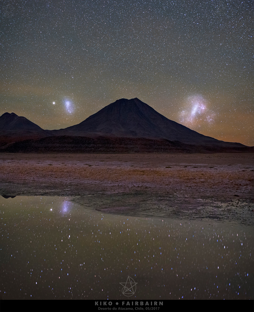
Magellanic Mountain
2018年4月27日 星期五
Commercial Lunar Payload Services
"NASA's release of a draft request for proposal for the delivery of lunar payloads to the Moon via commercial services is the latest step in the agency's expanding efforts in Lunar Exploration combined with support for the development of a the commercial space industry. NASA requires transport services to the lunar surface for instruments and technology demonstration payloads. This DRFP is the latest step in a long-running effort by NASA to support the development of commercial lunar capabilities considering the Moon as a destination for future human spaceflight. In the DRFP, NASA seeks to contract with the commercial sector to deliver scientific payloads to the Moon."
from NASA Watch https://ift.tt/2HwARvr
via IFTTT
NASA Sets Sights on May 5 Launch of InSight Mars Mission
April 27, 2018
from NASA https://ift.tt/2HzYIdy
via IFTTT
Trying To Understand What NASA Is Saying About Resource Prospector
|
|
1. Has the Resource Prospector mission been cancelled by NASA? If so when was it cancelled, who cancelled it, and why was it cancelled?
2. Will NASA be issuing a public statement with regard to the cancellation of the Resource Prospector mission?
3. Will NASA be responding to the letter sent by the LEAG on the topic of the Resource Prospector mission cancellation?
4. How much has NASA spent to date on the Resource Prospector mission?
5. Will any Resource Prospector- related activities continue after the cancellation of the mission itself? If so what activities will continue?
6. Was Administrator Bridenstine referring to the Resource Prospector mission in his tweet?"
from NASA Watch https://ift.tt/2HBluCc
via IFTTT
Montana, Vermont Students to Speak with NASA Astronauts on Space Station
April 27, 2018
from NASA https://ift.tt/2KmwjWq
via IFTTT
Dividing Line

ISS Daily Summary Report – 4/26/2018
April 27, 2018 at 12:00AM
from NASA https://ift.tt/2KlK3k3
via IFTTT
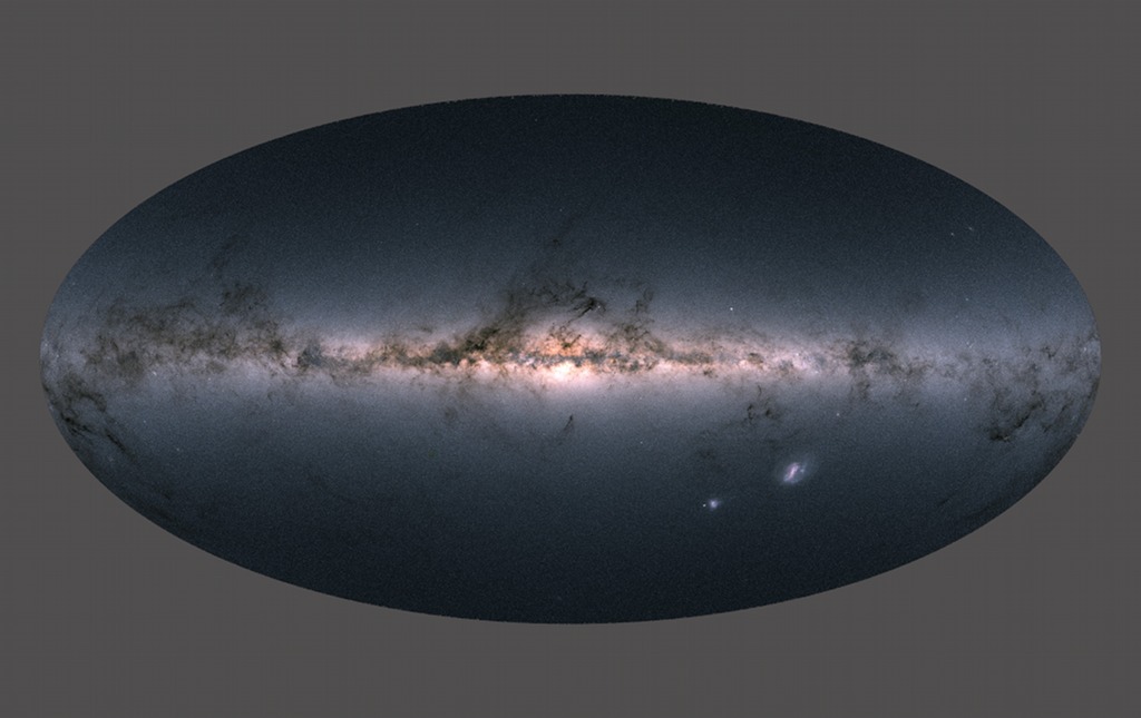
Gaia's Milky Way
2018年4月26日 星期四
Lunar Community Responds To Resource Prospector Cancellation
LEAG Letter To NASA Administrator Bridentine Regarding Resource Prospector Mission
"We wrote to Drs. Gerstenmaier and Zurbuchen to describe the community-wide support for RP on 2 March 2018, after the redirection for this initially HEOMD-led mission to be shared with the new Lunar Exploration and Discovery Program within SMD. We now understand RP was cancelled on 23 April 2018 and the project has been asked to close down by the end of May. This cancellation apparently stemmed from the transfer of RP from HEOMD to SMD due to lack of FY18 funding within the AES program and a misalignment between RP's goals and schedule and the new lunar program within SMD (which has different goals, timelines, and insufficient capability to deliver the RP payload). This action is viewed with both incredulity and dismay by our community, especially as the President's Space Policy Directive 1 directs NASA to go to the lunar surface. RP was the only polar lander-rover mission under development by NASA (in fact, by any nation, as all of the international missions to the lunar poles are static landers) and would have been ready for preliminary design review at the beginning of 2019."
Resource Prospector, NASA
from NASA Watch https://ift.tt/2r2P0W3
via IFTTT
Greece and the Aegean and Ionian Seas

NASA OIG Report On Commercial Resupply: Concerns With Dream Chaser
NASA OIG Audit of Commercial Resupply Services to the International Space Station
"However, despite a requirement to compete task orders among all contractors, NASA approved sole-source awards for all 31 CRS-1 missions and the 8 CRS-2 missions awarded as of December 2017. With the addition of a third contractor under CRS-2, we believe NASA has more flexibility to compete task orders or possibly open the contract to new entrants through its On-Ramp clause that allows NASA to recompete contracts with new contractors for any missions beyond the guaranteed six. In addition, we believe NASA could realize substantial savings if Sierra Nevada uses a less expensive launch vehicle than the Atlas V currently planned for the company's first two missions.
... we question as premature $4.4 million paid to Sierra Nevada to begin certifying its second Dream Chaser configuration. We believe ISS Program officials should have delayed these payments until after the first Dream Chaser configuration is successfully demonstrated.
... Although less risky than the CRS-1 missions, all three contractors face technical and schedule risks as they prepare for their CRS-2 missions. Development and launch of the Dream Chaser spacecraft poses the greatest technical and schedule risk to NASA due to its lack of flight history and Sierra Nevada's plan to not conduct a demonstration flight. Additionally, Sierra Nevada intends to only build one Dream Chaser and this raises concerns about potential schedule delays if an anomaly or failure occurs."
from NASA Watch https://ift.tt/2KgHYFX
via IFTTT
ISS Daily Summary Report – 4/25/2018
April 26, 2018 at 12:00AM
from NASA https://ift.tt/2HPxUFB
via IFTTT
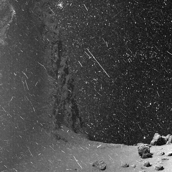
The Snows of Churyumov Gerasimenko
2018年4月25日 星期三
NASA Starts To Confirm SLS Changes It Denied Last Week
|
|
Radical Shift in SLS Launch Plans Discussed at MSFC (Update), Earier post
from NASA Watch https://ift.tt/2HrEbIi
via IFTTT
That Time The Outer Space Skype Thing Did Not Work
"MS. WANG: ISS, this is headquarters. How do you hear us? (Laughter.) ISS, this is headquarters. How do you hear us? It is 220 million miles away. ISS? This is headquarters. How do you hear us? I'm being told in my ear that we're connecting through Johnson Space Center right now.
THE VICE PRESIDENT: Did you pay the bill? (Laughter.)
MS. WANG: ISS, this is headquarters. How do you hear us?"
The @NASA HQ PAO folks did a really nice job on the @VP visit for @JimBridenstine's swearing in ceremony today. Everything went smooth. As for the @Skype call to ISS in outer space: make the crew phone home once in a while and their number will appear in your app as a recent call
— NASA Watch (@NASAWatch) April 23, 2018
from NASA Watch https://ift.tt/2HLX2gu
via IFTTT
Newt Gingrich Hints At Anti-SLS Whisper Campaign
Newt Gingrich: A glimpse of America's future in space in 2024, Fox
"If the Trump-Pence team pushes it, Falcon Heavy rockets could have more than 100 launches through 2024. The New Glenn, which will lift almost as much as the Falcon Heavy and will be rated to carry humans from Day One, could add another 20 flights between 2020 and 2024. Together, these approximately 120 heavy commercial flights would lift as much payload as 60 of NASA's Space Launch System (SLS) flights. However, there will be at most four SLS flights by end of 2024, according to current plans. Each reusable commercial flight will also cost less than $100 million, while SLS flights will cost $700 million to $1 billion per launch."
- Trump Transition Team Wants Old Space Vs New Space Smackdown, earlier post
- Newt Gingrich Thinks SLS May Become a Museum Piece - Soon, earlier post
Gingrich thinks that #ulcats and @nasa_sls will coexist briefly and that SLS could become a museum piece as a result of cost and performance
— NASA Watch (@NASAWatch) May 1, 2017
from NASA Watch https://ift.tt/2r0z0Ee
via IFTTT
Celebrating National Park Week With a View of Mount Rainier

Tom Cremins Is Acting Chief of Staff
NASA Internal Memo: Tom Cremins Appointed Acting Chief of Staff
"I wanted to let the workforce know that I have asked NASA veteran Tom Cremins to serve as my Acting Chief of Staff on an interim basis while I transition into the job of NASA Administrator. Tom led the overall transition effort and was critical to Robert Lightfoot's work to lead the agency over the past 15 months, and I know I will benefit from his 25 years of diverse NASA leadership experience. Tom will continue to serve as the Associate Administrator for Strategy and Plans, as he has since November 2015. I am grateful to Tom for his willingness to help in this role until I bring aboard a permanent Chief of Staff. Ad astra, Jim Bridenstine"
from NASA Watch https://ift.tt/2qVPNsU
via IFTTT
NASA Invites Media to Briefing on Next Earth-Observing Mission
April 25, 2018
from NASA https://ift.tt/2KbYc3c
via IFTTT
US Cargo Spaceship Set for Departure from International Space Station
April 25, 2018
from NASA https://ift.tt/2qXGjxf
via IFTTT
ISS Daily Summary Report – 4/24/2018
April 25, 2018 at 12:00AM
from NASA https://ift.tt/2HsEC5j
via IFTTT
Media Invited to Orbital ATK Cargo Launch from Virginia
April 25, 2018
from NASA https://ift.tt/2HqrEAU
via IFTTT
2018年4月24日 星期二
House Passes American Space Commerce Free Enterprise Act
House Approves American Space Commerce Free Enterprise Act
"The U.S. House of Representatives today unanimously passed the American Space Commerce Free Enterprise Act (H.R. 2809), which simplifies and strengthens the space-based remote sensing regulatory system, enhances U.S. compliance with international obligations, improves national security and removes regulatory barriers facing new and innovative space operators. The bill is sponsored by House Science, Space, and Technology Committee Chairman Lamar Smith (R-Texas)."
from NASA Watch https://ift.tt/2HJZN1U
via IFTTT
Hooray! NASA Has Yet Another Strategic Plan
"NASA inspires the world with our exploration of new frontiers, our discovery of new knowledge, and our development of new technology. Our work benefits Americans and all humanity. Since NASA's inception in 1958 to present day, the Agency's history is written with each unique scientific and technological achievement. We have landed people on the Moon, visited every planet in the solar system, touched the Sun, and solved some of the core mysteries of our home planet. Today, our Nation's economic prosperity, National security, and cultural identity depend on our leadership in aeronautics, space exploration, and science. NASA accepts the challenge to continue our legacy of achievement and greatly expand the benefits we provide to mankind. Our success will be determined largely by the planning and investments we undertake today. This commitment is what drives our Vision, Mission, and overarching approach that form the core of our 2018 Strategic Plan."
One thing to note: the whole "Journey To Mars" thing is more or less gone. Mars, while mentioned, is no longer the agency's prime destination for human spaceflight. The Moon is now that prime focus for human spaceflight. How long before NASA tosses everything up in the air again?
from NASA Watch https://ift.tt/2HoJ5Wp
via IFTTT
Behold the Northern Lights

Gravity’s Rainbow

ISS Daily Summary Report – 4/23/2018
April 24, 2018 at 12:00AM
from NASA https://ift.tt/2qXfl83
via IFTTT
2018年4月23日 星期一
Vice President Pence Swears in New NASA Administrator Jim Bridenstine
April 23, 2018
from NASA https://ift.tt/2vEp1tN
via IFTTT
HBR: Since 2006 NASA has been in "the network model"
The Reinvention of NASA, Harvard Business Review
"NASA today is a very different beast from the NASA of the 1960s. Though many would call that decade NASA's golden age, we'd argue that NASA's innovation and influence is even greater today."
"Since the Apollo program, NASA has faced funding cuts, competition from other nations for space leadership, and a radical restructuring of its operating environment due to the emergence of commercial space - all of which have forced the organization to change its ways of thinking and operating."
from NASA Watch https://ift.tt/2Ho6Hqe
via IFTTT
Vice President Pence to Swear in New Agency Administrator; Airing on NASA Television
April 23, 2018
from NASA https://ift.tt/2qSgaPi
via IFTTT
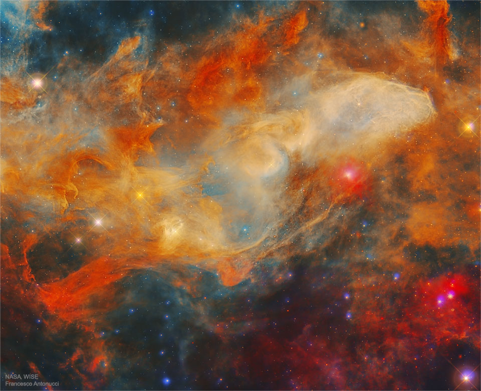
The Blue Horsehead Nebula in Infrared
2018年4月22日 星期日
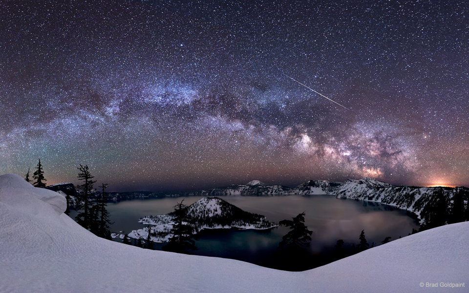
Meteor Over Crater Lake
2018年4月21日 星期六
Future Astronaut Takes A Lone Stand
Why a 7 year old walked out of school alone, CNN
"Seven-year-old Havana Chapman-Edwards was the only student at an Alexandria, Virginia, elementary school to participate when students across the nation walked out of school in support of school shooting victims, according to her mother."
from NASA Watch https://ift.tt/2vBACtD
via IFTTT
TESS Launch Close Up
2018年4月20日 星期五
Bridenstine To Be Sworn In On Monday
NASA Invites Media to Swearing-In of New Administrator James Bridenstine
"Media are invited to see Vice President Mike Pence swear in Jim Bridenstine as NASA's new administrator at 2:30 p.m. EDT Monday, April 23, at the agency's headquarters in Washington. The ceremony will air live on NASA Television and the agency's website. Following the swearing-in, Vice President Pence and newly sworn-in NASA Administrator Bridenstine will speak live with three NASA astronauts currently living and working aboard the International Space Station."
from NASA Watch https://ift.tt/2F4Bs1g
via IFTTT
NASA Invites Media to Swearing-In of New Agency Administrator
April 20, 2018
from NASA https://ift.tt/2HCTFIS
via IFTTT
NASA Awards Construction Contract for Instrument Development Facility
April 20, 2018
from NASA https://ift.tt/2J9vGht
via IFTTT
The Galápagos Islands

NASA Astronauts on Space Station to Speak with Students from Florida, Texas
April 20, 2018
from NASA https://ift.tt/2F2tplN
via IFTTT
ISS Daily Summary Report – 4/19/2018
April 20, 2018 at 12:00AM
from NASA https://ift.tt/2vsqCml
via IFTTT
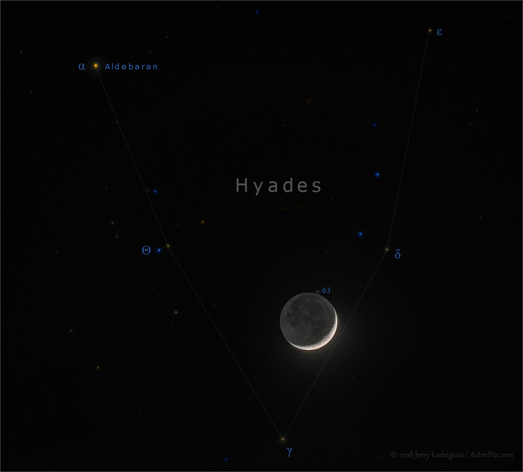
Moon in the Hyades
2018年4月19日 星期四
Statements on Jim Bridenstine’s Senate Confirmation as NASA Administrator
April 19, 2018
from NASA https://ift.tt/2HgovYb
via IFTTT
Celebrating 28 Years of the Hubble Space Telescope

ISS Daily Summary Report – 4/18/2018
April 19, 2018 at 12:00AM
from NASA https://ift.tt/2HdTkIZ
via IFTTT
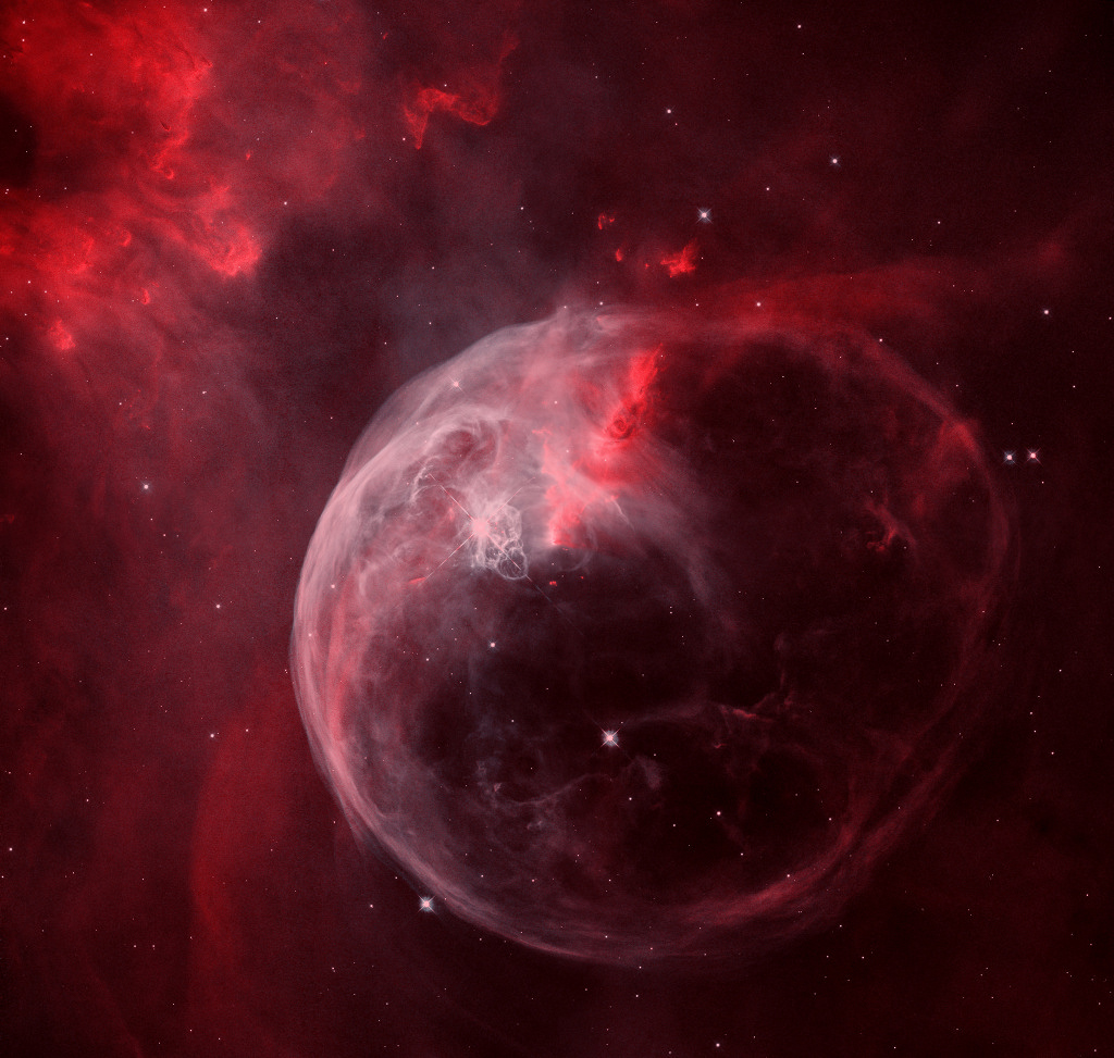
NGC 7635: The Bubble Nebula
2018年4月18日 星期三
TESS Mission

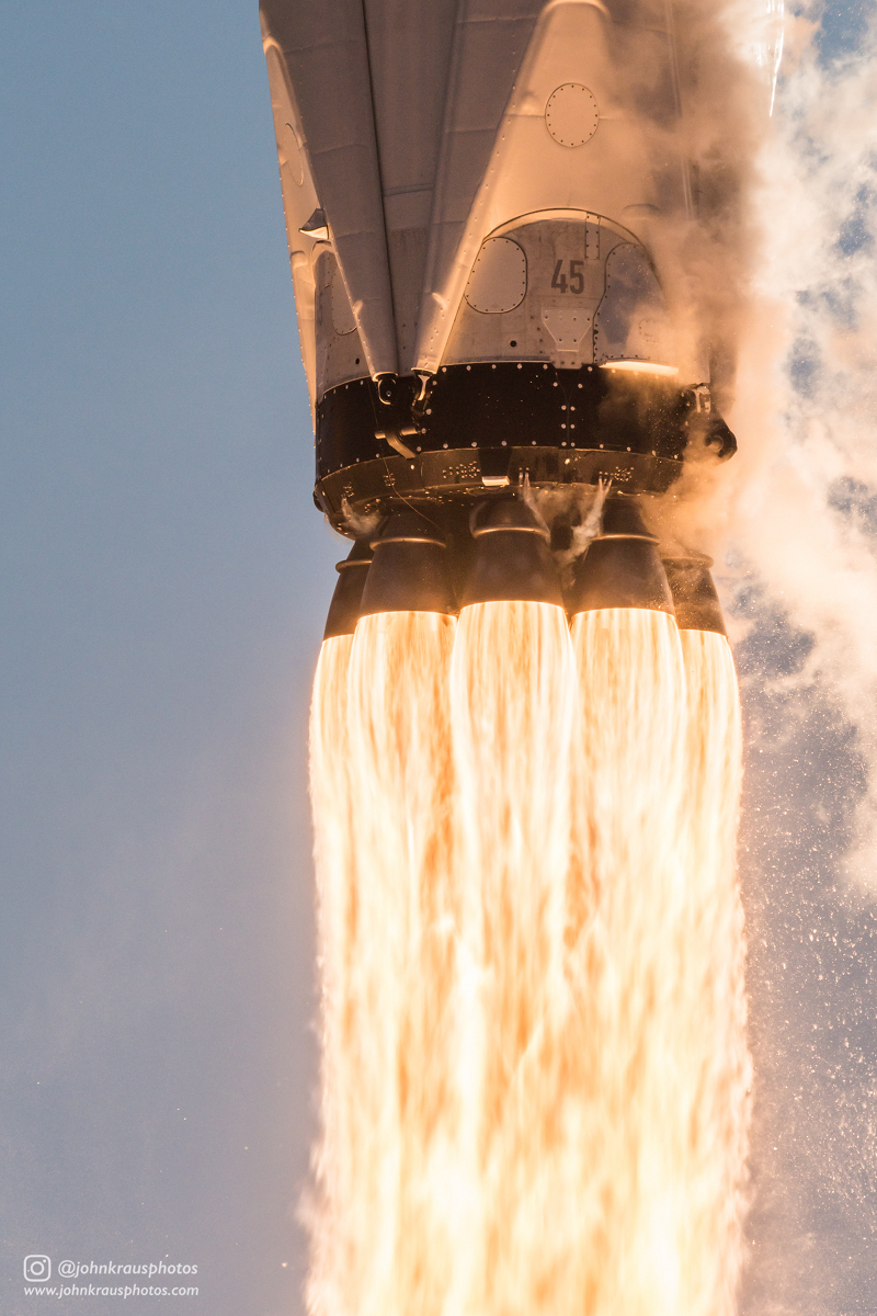
On Wednesday, April 18th at 6:51 p.m. EDT, SpaceX successfully launched NASA’s TESS spacecraft from Space Launch Complex 40 (SLC-40) at Cape Canaveral Air Force Station, Florida. Following stage separation, Falcon 9’s first stage successfully landed on “Of Course I Still Love You,” SpaceX’s droneship stationed in the Atlantic Ocean.
Falcon 9 delivered TESS to a highly elliptical orbit and the spacecraft was deployed approximately 49 minutes after liftoff. You can watch a replay of the launch below and find more information about the mission in our press kit.
from SpaceX News https://ift.tt/2Ha3LkS
via IFTTT
NASA to Discuss Demonstration of New Space Exploration Power System
April 18, 2018
from NASA https://ift.tt/2HctcOS
via IFTTT
ISS Daily Summary Report – 4/17/2018
April 18, 2018 at 12:00AM
from NASA https://ift.tt/2Hudmm5
via IFTTT
NASA TV Updates Launch Coverage for Planet-Hunting Mission TESS
April 18, 2018
from NASA https://ift.tt/2qLO1d0
via IFTTT
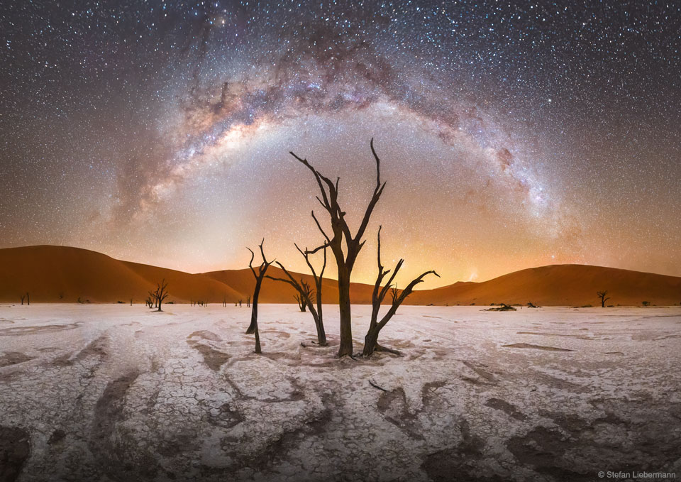
Milky Way over Deadvlei in Namibia
2018年4月17日 星期二
Curiosity Update, sols 1972-2026: Completing the Vera Rubin Ridge Walkabout

Following 200 sols of work, Curiosity's walkabout of the top of Vera Rubin Ridge (begun back around sol 1814) is complete. Curiosity mission style is to perform one or two surveys of a field site with remote sensing and contact science instruments before committing to drill locations. A first attempt at drilling into Vera Rubin Ridge, at a site named Lake Orcadie, on sols 1977 and 1984, did not succeed in collecting any sample. They didn't hang around at Lake Orcadie, instead traversing to several science-rich spots to characterize the ridge. Some spots had notable hematite concentrations, while others had weird collections of rocks.
Here's a view of the workspace at Lake Orcadie where Curiosity attempted drilling. The base photo was taken after the dump of leftover Ogunquit Beach sample but before all of the brushing and drill attempts.
You can see that the drill "walks" a little bit initially until it begins to bite into the rock -- this is expected behavior because Curiosity can't use the drill stabilizers anymore. It looks exactly like when I try to drill a hole in a wall without using an awl or nail to peck a starter hole first -- on rotation the drill shifts to the right until it bites.
I produced an enlarged version of the animation and tracked the motion of one of the drill stabilizers as a proxy for drill bit depth. It looked like it only got about a centimeter into the rock. That's enough to generate an interesting-looking pile of tailings, but unfortunately not deep enough to acquire sample. The drill bit has to penetrate 1.5 centimeters before the sleeve around the bit makes contact with the rock, trapping powder inside the drill bit assembly and augering it up into the sample chamber above the drill bit.
They went for it again on sol 1983, and made even less progress.
Although it's frustrating that the drill didn't get deep enough to acquire sample, it did scrape up fresh powder that was duly examined with ChemCam and APXS. I'm looking forward to learning more about what they observed!
Why didn't it work? It's impossible to know for sure. It likely did not help that the rover was using rotary-only drilling rather than rotary-plus-percussion drilling, a technique that the rover has not used on Mars before. (You can read more about drilling and the response to the drill feed failure here.) They were testing rotary-only drilling at Precipice when the drill feed failed. But based on what they understand about the rover and the rocks, the rotary-only drilling should work, unless the rock being drilled is harder than rocks that Curiosity has encountered before.
Therefore, the team considers it likely that the rocks on Vera Rubin Ridge are unusually hard. Which makes sense, if you think about it. The ridge is resistant to erosion; that's why it's a ridge! It's reasonable that the rocks themselves could be harder than Curiosity has drilled before. Not certain, but reasonable. Here's what Roger Wiens had to say about the question in his sol 1985 update:
The engineers are working on testing and validating rotary-plus-percussion feed-extended drilling. The next time they try to drill, they'll evaluate which technique they think is likely to produce a good result before proceeding.
Meanwhile, Curiosity drove on, continuing the study of the top of Vera Rubin Ridge. The last time I wrote about the walkabout, the rover had reached a hematite hot spot at the southern edge of the ridge, which is both topographically and stratigraphically high. Since then, the rover has traversed to the northeast to another hematite hot spot, crossing back down the stratigraphy. Here's an overview of the traverse. You can use the slider to change the image underneath the traverse map from Mars Reconnaissance Orbiter HiRISE color to the CRISM hematite map:
In the wider view at upper left, you can see that the rocks appear a buff color, crossed with very fine lighter tan veins, but that's just the color of the dust. Near the center of the image is a spot where air blasting away from ChemCam zaps has dusted off the rock, revealing a much more red color underneath. Zooming in at upper right, you also can see that the reddish rock has a shiny, reflective appearance, like it's been varnished. Also coming into view are some interesting chicken-feet white features scattered about the rock. Zooming in further at the lower right, you can see that where ChemCam has blasted, it seems to have blasted through a reddish surface to a grayer material below. And the fine vein is very bright.
Finally, there is the ChemCam imager view at lower left, which is the one I find most interesting. ChemCam is a black-and-white imager that sees in both visible and near-infrared wavelengths. In the near-infrared, dust and veins are very bright and the rock is very dark. Intriguingly, those chicken-scratch features, which may be crystals of some kind of mineral that grew in the rock as it was turning from mud into rock, are also bright to ChemCam. I hope they manage to get a ChemCam zap or two across those crystals to see what they are. Curiosity has seen them in a couple of other places, including at Seaforth on sol 1991.
At the northernmost reach of the drive, Curiosity got up to the richest hematite spot seen from orbit. Christopher Edwards had some pretty strong things to say about this spot on sol 2005:
While the rocks under the wheels are fascinating, so are the great views that Curiosity has been getting. Skies are usually clear in late winter, but they are exceptionally clear this year, and the rover is also sitting on a local topographic high, so the vistas have been phenomenal. I mean, just look at this detail they're getting on the slopes of Mount Sharp:
The clear skies aren't going to last much longer; the mission bloggers have been mentioning dust devil activity picking up as the spring season approaches.
Toward the end of the walkabout, Curiosity spotted an odd-looking pile of rocks in the distance.
Driving up to it, the team observed a diverse collection of float rocks. It was like somebody had collected a bunch of samples of typical Gale crater float rocks and then dumped them out at this site.
The walkabout is now wrapping up with some contact science on a windblown sand ripple. With their walkabout complete, it's now time to try drilling again. They'd like to drill in as many as four different locations on Vera Rubin Ridge, as I explained in my last update. The future drill sites would be in both "gray" and "red" material from the upper elevation part of the ridge; at a lower-elevation site on the ridge; and into the Murray formation just below the distinct ridge rocks. Let's all hope that the next time I have a chance to write about Curiosity's ongoing mission, it'll be to talk about a return to drilling.
Sol 1972 update by Abigail Fraeman: Finishing Up Observations of Ogunquit Beach (21 Feb 2018)
Tosol we planned to finish up our suite of observations on the "Ogunquit Beach" sand sample that was off-loaded from the rover over the weekend. As described in yesterday's blog, the rover had dumped two piles of the Ogunquit Beach sample - a pre-sieved and post-sieved portion - on the ground in front of us. Because we spent yestersol observing the pre-sieved dump pile with MAHLI and APXS, we are now ready to blast that pile around with ChemCam's laser, which we will do in today's plan!
We will also continue to collect observations to characterize the bedrock in front of us. We have planned several APXS and MAHLI observations on the area around "Lake Orcadie." The small offsets between these data and previous measurements will enable us to understand small scale variability in the chemistry of the target. We will also take an additional ChemCam LIBS observation and associated Mastcam documentation image of a bedrock target "Peterculler."
Sol 1973 update by Mark Salvatore: Go for Drilling! (22 Feb 2018)
Curiosity is officially go for drilling the "Lake Orcadie" target! After more than a year's wait for the drill to come back online, the rover planners and engineers are confident and ready to proceed with a test of a new drilling method in the coming days.
Because there is only so much data volume and rover power to go around, performing drill activities must temporarily come at the expense of scientific investigations (although you'd be pressed to find a disappointed science team member this week, as the drilling campaign will bring loads of new scientific data!). As a result, with the exception of some environmental observations by the Rover Environmental Monitoring Station (REMS) instrument, today's plan does not have any targeted scientific observations within it. Today will instead be dedicated to drill preload activities and imaging for engineering and rover planning purposes in preparation for a full test of the revised drilling operations.
The name "Lake Orcadie" refers to an ancient lake that was once located in Scotland and is now a series of sedimentary deposits preserved in the geologic record. The Lake Orcadie sediments in Scotland helped geologists to reconstruct the environmental history of the Devonian period on Earth, when fish began to diversify. Considering this target will be the first drill location on Vera Rubin Ridge (VRR), perhaps these new data will help inform us as to what sort of geologic and environmental conditions were present during this time in the history of Gale crater.
Sols 1974-1976 update by Christopher Edwards: Ready, Set…Hold (27 Feb 2018)
After a successful drill preload test, Curiosity was primed to drill for the first time in about a year. Unfortunately, due to a light downlink from the Mars Odyssey spacecraft, we didn't get all the images down needed to safely carry out the drill activity in this weekend's plan. Instead, we'll push the drill activity out until we get the needed images down to help ensure it will complete successfully! Until then the view of the arm preload activity provides tantalizing hints of great things to come.
However, just because we couldn't carry out the drill activity as planned, that doesn't mean the team would let the rover sit idle. In fact, quite the opposite. The science operations team immediately started planning backup science activities. The team decided to carry out activities on two contact science targets with MAHLI imaging and APXS chemistry. These targets, dubbed "Rockall" and "Benbecula", will continue to help us characterize the composition and fine-scale textures of the bedrock around our upcoming drill location. These activities will provide valuable geologic context to the drill and help assess the variability of the bedrock in this area. A slew of ChemCam and Mastcam images are also being acquired to further this goal. It won't be long until the other instruments inside the rover body get to sample the fantastic geology of the Vera Rubin Ridge. Stay tuned this coming week for the results of the drill activities. The science team can't wait!
Sol 1977 update by Scott Guzewich: Return of the Drill (26 Feb 2018)
Curiosity has returned to its primary mission of drilling rocks on Mars (at "Lake Orcadie") in an attempt to rescue critical science on the Vera Rubin Ridge from the clutches of vile mechanical failures.
Little does Curiosity know about the secrets of martian history written in the Vera Rubin Ridge, but they will soon be unveiled through the new procedure of feed-extended drilling.
When completed, this incredible technique will illuminate martian history and geology for the small band of scientists and engineers struggling to restore drilling to Mars…
Sol 1978 update by Ken Herkenhoff: Examining drill tailings (28 Feb 2018)
The tactical planning schedule was delayed by 2 hours today so that we would have the latest data from Sol 1977 available for planning. When the data arrived, it quickly became clear that the feed-extended drilling did not complete as planned. However, the new drilling technique was partly successful, producing tailings from up to 1 cm below the surface. So we had to quickly react to this situation, and the Sol 1978 plan is focused on measuring the composition of the fresh drill tailings. This made for an interesting day for me as SOWG Chair!
First, Mastcam will measure dust in the atmosphere by looking at the Sun and the crater rim in the distance. Then Mastcam will acquire a multispectral set of images of the tailings. We don't want to risk disturbing the tailings pile by shooting ChemCam's laser at it, so ChemCam will take passive spectral of the pile instead. ChemCam and Right Mastcam will also observe soil target "Lock Snizort," bright veins at "Melby," and bedrock at "Uig HIlls." After a short nap, the arm will go to work on the drill tailings, taking MAHLI images from 25 and 5 cm above the pile, then placing the APXS for an overnight integration. Finally, the rover will sleep while the operations team decides what to do next.
Sol 1979 update by Scott Guzewich: Mars Strikes Back (28 Feb 2018)
It is an exciting time for the Curiosity team. Although the drill was able to create a hole, Mars stubbornly refused to let the drill reach a depth where a rock sample could be collected and has driven Curiosity away from "Lake_Orcadie".
Attempting to evade the dreaded impenetrably hard bedrock, a group of dedicated scientists and engineers established a new drill target "Lake_Orcadie2" roughly 7 inches to the right of the first target.
Obsessed with finding a suitable new drill location, Curiosity will thoroughly characterize this new location with APXS and MAHLI after brushing it with the dirt removal tool while also studying the wall and tailings from first drill hole with a ChemCam LIBS raster and Mastcam imaging.
Sols 1980 update by Rachel Kronyak: Back to science (1 Mar 2018)
Today, Sol 1980, we're taking a break from drilling activities to continue with our remote science campaign at our current location. We have three science blocks in today's plan, which we've filled to the brim with a variety of observations. In the early afternoon, we'll use Mastcam to make a multispectral observation on "Lake Orcadie 2," the location of our second intended drill target (which is just to the right of Lake Orcadie, pictured in the Navcam image above). We'll then take a Navcam movie to look for dust devils. Next up is a series of ChemCam LIBS observations to target Lake Orcadie 2, "Black Cuillin," and "St Kilda." Black Cuillin and St Kilda are repeat observations to take a closer look at small-scale features in our workspace. All ChemCam targets will also be documented with Mastcam images. We'll take an additional Mastcam mosaic of the "Dunbar" target to better characterize the stratigraphic stacking of rocks around the rover.
Later in the afternoon we have another science block, during which we'll use ChemCam to take a series of long-distance images of the Peace Vallis fan. After that, we'll take a set of Navcam movies to help us measure the velocity and height of clouds above us.
Our final science block will be first thing in the morning on Sol 1981, which we'll use to carry out some standard ENV observations, including a Mastcam tau, crater rim extinction, and a few Navcam movies.
Sols 1981-1983 update by Ken Herkenhoff: Second sample acquisition attempt (2 Mar 2018)
All of the data returned for the second drill target, called "Lake Orcadie 2," support the decision to attempt to acquire sample at that location using feed-extended drilling. So the weekend plan is focused on drilling, which is planned for the second sol (1982). But first, on Sol 1981, ChemCam and Right Mastcam will observe a potential location for dropping sample in the future and targets named "Ben Nevis" and "Moray." Mastcam will then measure dust in the atmosphere and Navcam will search for dust devils. Later that afternoon, Right Mastcam will look for changes in the sieved and unsieved Ogunquit Beach dump piles, and the ChemCam RMI and Right Mastcam will acquire mosaics of the alluvial fan near the north rim of Gale Crater. Overnight, APXS will integrate on air rather than surface materials to measure the amount of argon in the atmosphere, which is known to vary seasonally based on Mars Exploration Rover APXS data.
Feed-extended drilling dominates the Sol 1982 plan, with only REMS and DAN activities running in parallel. The drill will be retracted from the hole, and Mastcam will take pictures of the hole and the drill bit on Sol 1983. Then the rover will sleep in preparation for more work on Monday. Of course we are all hoping that the drilling goes well--we're looking forward to studying the drill hole and sample!
Sol 1984 update by Scott Guzewich: Searching for Softer Pastures (5 Mar 2018)
Vera Rubin Ridge is as hard as a rock! After two drilling attempts, Curiosity's drill was not able to dig into the bedrock sufficiently to collect a sample of rock at this location. Curiosity's engineers are continuing to refine the new drilling method. In the future, this might include adding percussion, which could enable drilling into harder rock. After learning this, the science team planned a series of Mastcam and ChemCam "passive" and LIBS observations of the attempted drill hole at "Lake Orcadie 2" (covered up by the turret in this image) in addition to contact science on the drill "tailings" (the powdered bits of rock ground up by the drill) with MAHLI and APXS. A ChemCam passive observation uses the instrument's ability to detect different wavelengths of light to get a sense of a rock's composition without using the laser to vaporize tiny bits of the rock surface. The team also planned another trick with ChemCam: long-distance image sequences of Peace Vallis on the far side of Gale Crater and a portion of the clay unit that represents part of Curiosity's future agenda.
Sol 1985 update by Roger Wiens: How Hard is a Rock? (6 Mar 2018)
Last week when the first Vera Rubin Ridge drill-hole attempts turned out to be too shallow at "Lake Orcadie", discussion in the team turned to the question of, "How hard is that rock? Is there a way to know before starting the drill hole how hard the rock will be, so we can anticipate whether Curiosity's new drill technique will be successful?" It turns out that the rover team has several indicators of rock hardness: a) retention of natural features such as craters, b) the imprints of wheel marks on the rocks, when we see them, c) scratch marks from the DRT brush, and d) laser pits from ChemCam. This turns out to be a lot of data, especially from ChemCam and MAHLI. However, no one has yet made a quantitative study of rock hardness vs. apparent laser pit depth or brush scratches. The problem is that other factors can affect how deep the pit or scratches look in our images, especially including lighting angle and rock texture and color, but also, for the laser, the distance from the rover and the focus quality. Even so, a study to determine apparent laser pit depth or scratch depth vs. hardness may be useful.
The classic Mohs mineral hardness scale was developed over 200 years ago, based on ten readily available minerals ranging from talc (hardness of 1) to diamond (hardness of 10). It is still used because of its simplicity-you can buy a kit with each of the representative minerals and try using them to scratch the mineral that you want to test. However, for quantitative measurements, most studies use the Vickers scale, which was defined 100 years ago and is reported in kg per square mm. It is traditionally measured by the size of the indentation left from a diamond tip with a given force applied.
Meanwhile, back on Mars, Curiosity will be driving away from this hard-rock location, with the first drive since Sol 1962, planned to go backwards for 30 meters in a northeasterly direction. Prior to leaving this site, ChemCam and Mastcam will make one more observation each of a meteorite, "Ben Nevis_2." The accompanying image shows the small iron clast with four bright glints, which are sunlight reflections off the metal made bare by previous ChemCam laser shots. Mastcam will also make crater rim extinction and basic tau (atmospheric visibility) observations. After the drive Mastcam, Hazcam, and Navcam will document the new rover surroundings. Navcam will take a zenith movie and a 360 degree observation. Mastcam will also take a clast survey image, ChemCam will take an RMI mosaic of the Yardang portion of Mt. Sharp, and will use AEGIS software to select an outcrop target near the rover for chemical analysis. DAN, MARDI, RAD, and REMS will also take data.
Sol 1986-1987 update by Roger Wiens: Clear Vistas on Mars (8 Mar 2018)
Seasons make a big difference for Mars vistas. Tosol Mars is at solar longitude 139, meaning that it is halfway between winter solstice and spring equinox in the southern hemisphere where Curiosity resides. The atmosphere around the globe is the clearest in southern winter. Once spring starts, turbulence increases and dust storms begin. The rover team is taking advantage of the clear skies to take long-distance ChemCam RMI mosaics of the terrain on Mt. Sharp and on the crater rim. We are especially interested in a Mt. Sharp unit characterized by features that look like yardangs, which are typically wind-sculpted elongated features in a landscape that is experiencing erosion. We're also very interested in the apparent fluvial channels seen descending from the crater rim. The accompanying Navcam image shows at least two channels (you may have to zoom in to see them). The one at the far right is named Peace Vallis and has already been the subject of some studies. We are curious - when was the last time that water flowed down these channels? Was it steady flow, or catastrophic? Is there evidence of snow and ice, or was the water more likely delivered as rain?
Under clear skies, Curiosity drove ~30 meters yestersol and is now stationed on a gravelly patch of ground. The rover is heading northeast along the top of Vera Rubin Ridge. With only gravel underfoot, the arm instrument teams decided to forgo contact science at this location. ChemCam and Mastcam will observe small bedrock targets "Sgurr nan Gilean" and "Braemar." Mastcam will use optical filters to observe the latter target. After a planned long northerly and slightly downhill drive aiming for 82 meters with visual odometry, imaging of the surroundings will be done by Hazcam, Navcam, and Mastcam. It will include a Mastcam clast survey. AEGIS software will use the Navcam images to pick a target for ChemCam to shoot. On the second sol of this plan ChemCam will take long-distance images of the yardang unit on Mt. Sharp and of the Peace Vallis area as noted above. Navcam will take several movies to look for dust devils and thin clouds. DAN, RAD, MARDI, and REMS will also take data.
Sol 1988-1990 update by Ryan Anderson: Stop and Smell the Argon (12 Mar 2018)
We found out this morning that in the Sol 1986 plan, ChemCam was marked as "sick" and did not run its sequences. But on the bright side, it's a repeat of a minor issue that we've seen before, and so ChemCam will be back in action in today's 3-sol plan.
The plan begins on Sol 1988 with a bunch of Mastcam observations. We have stereo mosaics of an area near the target "Golspie" and an area called "Loch Eriboll" that we are scoping out as a potential drill site, as well as a broader context mosaic that covers both areas. Mastcam will also make a multispectral observation in the drive direction. After that, with ChemCam back online, it will analyze the target "North Harris" and Mastcam will take a documentation image. Later in the day, MAHLI will take some pictures of the targets "Barkeval" and "North Harris" and then APXS will do a quick analysis of "Barkeval" and an overnight measurement of "North Harris".
On Sol 1989, MAHLI will inspect our battered wheels, and then we will drive for about 45 meters, followed by the usual post-drive imaging. APXS will pull another all-nighter, this time in the stowed position. By collecting data while not touching a rock, APXS can measure the amount of argon in the martian atmosphere, which is useful since unlike carbon dioxide and water vapor, argon doesn't freeze out of the atmosphere at the poles every winter!
Speaking of the atmosphere, Sol 1990 was dedicated to lots of atmospheric observations. Mastcam has some observations of dust in the atmosphere in the early morning and early afternoon, and Navcam will watch for clouds at those times as well. Navcam also has some early morning observations of the atmospheric "phase function": basically, how bright the sky is at different angles from the sun. Navcam will also watch for dust devils in the afternoon.
Sol 1991-1992 update by Ryan Anderson: Taking our time for science (12 Mar 2018)
After a successful weekend plan, the team decided that for the sol 1991-1992 plan, we would trade a longer-distance drive in favor of some "touch and go" contact science. This ensures that we have a good record of the variations in chemistry and rock texture as we drive along the Vera Rubin Ridge. The plan starts with a short APXS observation of the target "Seaforth Head" along with MAHLI images of the same target. ChemCam and Mastcam also join in the fun, analyzing Seaforth Head as well as the target "Canisp". After those observations are finished, Curiosity will drive about 15 meters and collect the usual post-drive images.
On Sol 1992, we have an untargeted science block full of ChemCam activities. ChemCam will use autonomous targeting to analyze a patch of bedrock, and then will observe the titanium calibration target. After that, ChemCam will take advantage of the clear skies and nice vantage point here on the top of the Vera Rubin Ridge to do a big 10x2 RMI mosaic of part of the Peace Vallis fan. Mastcam will observe the same area with its right eye to provide color and context for the RMI. The plan wraps up with a Navcam movie to watch for clouds.
Sols 1993-1994 update by Michelle Minitti: Castle in the Sand (15 Mar 2018)
As we drive east across the top of "Vera Rubin Ridge" - backwards no less! - we encountered another nice patch of bedrock in Curiosity's workspace today, motivating multiple observations before we hit the road once again. The bedrock in front of us resembled that which we studied on Sol 1991, where we imaged the target "Seaforth Head" . Seaforth Head exhibits small crystals like the ones we found at the "Jura" outcrop, and we hoped that today's workspace might turn up more crystals. To look for them, we planned a Mastcam M100 mosaic over a wide swath of the workspace. Our more detailed assessment of the bedrock will include coordinated observations of the gray bedrock target "Stirling Castle" with MAHLI, APXS and ChemCam. This target's name also gave us a chance to honor one of the rover planners operating the rover today, Stirling Algermissen! ChemCam will acquire a second raster on "Dunottar," bedrock which is rough and reddish at its base and smooth and gray at its top.
ChemCam will be kept very busy imaging far away targets and the sky in this plan. Nine overlapping RMI images of Peace Vallis will be acquired in an effort to combine them into a single image of higher resolution. As we did on Sols 1986-1987(link to the Sol 1986-87 blog), we will image the yardang unit on the flank of Mt. Sharp with two long distance RMI mosaics. These mosaics will help us increase our understanding of the internal structure of this unit. Just as we often use ChemCam in passive mode to look at the spectroscopic signature of rocks around us, in this plan we will use that same mode to look at the sky. ChemCam passive observations of the sky allow us to estimate concentrations of aerosols and trace gases in the atmosphere. To ensure the passive sky observation is well-calibrated, ChemCam will acquire passive spectra from the ChemCam calibration targets both before and after the sky observation.
The atmosphere will get more attention after our ~35 m drive, with images to measure the amount of dust in the atmosphere and movies that seek out clouds. APXS will also get its turn, measuring the amount of atmospheric Ar as the turret remains stowed on the night of Sol 1994.
Sols 1995-1997 update by Michelle Minitti: Under Durness (16 Mar 2018)
The science team gave Curiosity a workout in this plan, using just about every watt of power available to carry out a full slate of activities. Sol 1995 starts off with a bang - three ChemCam rasters and a Mastcam 360 mosaic! ChemCam will first shoot "Durness," a flat, gray, apparently wind sculpted slab of bedrock in the workspace. Next up for ChemCam is "Paisley," a faceted cobble of bedrock cut by sulfate veins, and last is "Fingals Cave," a bright white exposure of sulfate vein.
The arm instruments get to work next. MAHLI will image Durness, which will show the ChemCam shots across the target, followed by DRT brushing of the target. APXS will analyze Durness and Paisley overnight, and then early in the morning of Sol 1996, MAHLI will return to Durness for more imaging on its now dust-cleared surface. MAHLI imaging of Paisley ends the arm work, and will capture the ChemCam raster spots and the areas cleared of dust by the ChemCam laser.
Before we drive on Sol 1996, the rover will acquire Mastcam multispectral observations of the DRT spot on Durness and across the "Vera Rubin Ridge" in the direction of a particularly strong hematite signal seen from orbit that we are driving toward. After the drive, Curiosity will acquire two ChemCam observations using the AEGIS automated targeting algorithm, and spend time observing the atmosphere. Mastcam and Navcam images and movies measuring dust in the atmosphere and looking for dust devils and clouds will take place both early in the morning and in the afternoon of Sol 1997. APXS will acquire another Ar atmospheric measurement overnight on Sol 1997. Regular DAN, RAD and REMS measurements keep the rover working in those small windows where nothing else is going on!
Sol 1998 update by Rachel Kronyak: Checking out the scenery (19 Mar 2018)
Today was a fairly quiet day of planning on Mars, the reason being that most of the MSL science team is currently attending the Lunar and Planetary Science Conference (LPSC) in Houston, Texas. LPSC kicks off today and is a really exciting time to hear all about the planetary-focused research being conducted all over the world. It's also a great time to make connections and collaborate with fellow scientists!
Today we planned for Sol 1998, which was mostly devoted to remote science observations as we drive along the VRR to our next area of interest. We have a hefty, 2-hour science block, which starts off with a couple of Mastcam multispectral observations on the "Red Hill" and "Red Cuillin" areas. These observations are intended to investigate the spectral properties of the terrain just ahead of the rover. We'll then take a stereo mosaic of the "Sgurr Alasdair" target to document the stratigraphic relationships of nearby rocks. After Mastcam, we'll take a suite of ChemCam observations. First, we'll take LIBS measurements on bedrock targets "Ochil" and "Orval," followed by RMI mosaics of yardang and fan features off in the distance.
Following our science block, the rover will perform a drive and take some standard post-drive images. We also have a post-drive science block, during which we intend to carry out a few ENV observations to monitor atmospheric and cloud properties.
Today I served as Mastcam PUL-1 and am working my shift remotely from the conference center at LPSC. I will be presenting some of my PhD research later this week, focused on fractures and veins that we've observed using the Curiosity rover and HiRISE orbital camera.
Sol 1999 update by Scott Guzewich: Party like it's (Sol) 1999 (21 Mar 2018)
Curiosity is but 1 sol away from a major mission milestone, but work always comes before celebrations. Today our major decision was whether to perform contact science at the current location and conduct a short drive, or make a longer drive toward stop #12 on the Vera Rubin Ridge campaign (in the middle distance on the right side of the image). Today's team decided quickly to choose the latter option. But prior to the drive, we had room for a short science block that included ChemCam and Mastcam analysis of a bedrock target termed "Mangersta", measurements of dust in the atmosphere, and a search for dust devils. Then Curiosity will boogie toward stop #12, and after getting there, conduct a ChemCam AEGIS activity.
Sol 2000 update by Christopher Edwards: Roving for 2000 Martian Days (22 Mar 2018)
Today marks a milestone for Curiosity. Our trusty Martian rover has spent 2000 sols exploring Gale Crater helping to unravel the geologic history preserved in the rocks. We've observed a huge variety of past environments ranging from conglomerate rocks that indicate flowing surface water to mudstones that document a time when Gale crater contained an ancient lake. In today's plan, Curiosity is continuing its exploration of past environments preserved within Gale crater, further examining the Vera Rubin Ridge. Curiosity is continuing to make its way to the location where the strongest orbital signature of hematite is observed. In today's plan, we're carrying out remote sensing activities to examine layering in the rocks, as well as contact science on the target dubbed "Sgurr of Eigg" (just off the bottom of this image) to characterize the unit's chemistry and fine-scale morphology. We'll continue these types of activities over the weekend plan to refine our understanding of this workspace.
While some of us on the science team were busy planning activities for Curiosity's plan, many of the MSL science team members were busy attending the Lunar and Planetary Science Conference (LPSC). Today coincides with the majority of the MSL presentations discussing the new science being carried out by the team. In fact, I'm also attending LPSC but am taking a break to help plan Curiosity's activities from my hotel room at the conference center. It just goes to show, you can help drive a rover from almost anywhere!
Sol 2001 update by Abigail Fraeman: A Mars Odyssey (23 Mar 2018)
Geology Science Theme Group Leader Prof. Chris House kicked off our planning today by playing a rousing rendition of "Also sprach Zarathustra" over the phone line. Hearing the theme song to the famous movie 2001: A Space Odyssey was the perfect start to sol 2001 planning and inspired us to chose two new target names that were as close to A Space Odyssey as we could get: "Boddam" ((David) Bowman) and "Kirkcudbright" ((Stanley) Kubrick).
Curiosity is currently sitting in front of a steep outcrop that shows some interesting geologic relationships between rocks in the Vera Rubin Ridge. We acquired some great images of these rocks in yestersol's plan, so today we were focused on understanding the properties of the rocks at our feet. In the first sol of the plan, sol 2001, we will be collecting MAHLI images of a target named "Apin," and doing DRT, MAHLI, and APXS on a target named "Brora."
The second sol, sol 2002, will focus on remote sensing, with ChemCam observations on targets named Boddam, "Sgurr of Eigg," and Kirkcudbright. The ChemCam observations will be accompanied by Mastcam documentation images. We will also be taking a multispectral observation of the DRT targets from tosol (Brora) and yestersol (Sgurr of Eigg), some multispectral images of the landscape in front of us, and some additional color images of the vertical rocks in front of the rover to complement the data we collected yestersol. We'll top off the science block with a dust devil movie and dust devil survey. We'll stay up after dark on sol 2002 to collect additional nighttime MAHLI images of Appin and Brora.
On sol 2003 we will have a bunch of dedicated environmental science measurements, including a tau to measure the dust in the atmosphere, a Navcam 360 sky survey, a Navcam zenith and suprahorizon movies, and a crater rim extinction image. We'll squeeze in another ChemCam RMI mosaic of some distant features in Mt. Sharp. Sol 2003 will finish with an ~50 m drive towards an area where we see some of the strongest spectral signatures of hematite on the ridge in orbital data. We'll take a standard set of post-drive images over the weekend to set us up to characterize this location in the sol 2004 plan. It will be very exciting to see the exact rocks that are the source of the orbital signature which helped us realize the importance of Vera Rubin Ridge over five years ago!
Sol 2004 update by Abigail Fraeman: Let's try that one more time (26 Mar 2018)
For Sol 2004, Curiosity threw it back to the 2004's sleeper hit Mean Girls when the rover said, "Stop trying to make 'drive' happen." The weekend drive stopped after just a few meters due to a high current warning from the right middle wheel. We were able to assess all of the drive data this morning and decided there wasn't any real risk to the vehicle. Instead, we just got unlucky because the combination of a small rock and the rover orientation made the middle wheel work a little harder than normal, and this tripped the limit warning. These things happen occasionally when you are autonomously driving a MINI-cooper sized rover on an entirely different planet!
The star of today's plan will be the drive that was planned for the weekend. We will start by backing up from the area where the weekend drive faulted out, and then continue along our original planned path from the weekend. We do have a very short science block before today's drive. During that time, we will investigate a brick-red rock, "Mousa," that was turned up by the rover's wheel using ChemCam and Mastcam multispectral data. We will also take a high resolution Mastcam image of a rock with an interesting texture named "Duncansby Head." After our drive, we will take a lot of post-drive images and an AEGIS ChemCam observation. As I mentioned on Friday's blog post, we are headed to the area on the ridge where we see the clearest orbital signature of hematite. I wonder if the bright red rocks at our feet are an indicator of things to come?
Sol 2005 update by Christopher Edwards: Squarely in the Red (28 Mar 2018)
After completing a nearly 55m drive, Curiosity found itself sitting right in the middle of the strongest spectral detection of hematite identified along its path up Mt. Sharp. This strong spectral signature is viewed both from orbit, where it was originally identified in Compact Reconnaissance Imaging Spectrometer data, and from the ground in Mastcam multispectral data. While Curiosity has definitely visited some areas that have the spectral fingerprint of hematite in previous sols, this is by far the best example we've seen over the mission. The MSL science team is still trying to figure out how this mineral formed and why we're finding it where we are. Today's parking spot will likely prove key to unraveling the geologic history of the Vera Rubin Ridge, when combined with other data acquired in Gale Crater.
It was a busy day for Curiosity and the science team had a fabulous workspace to examine. Two contact science targets ("Stranraer" and "Murchison") were chosen to help examine the variability in chemistry related to different targets identified in color Mastcam data. For example, the Murchison target appears to be darker red than some of the other rocks like the Stranraer target. A unique experiment with Mastcam was designed to characterize the light scattering properties of the unit by taking 7 different observations over the course of the day. Mastcam will observe how the same spot on the surface changes its reflectivity properties with changing illumination, with the goal of providing insights into the nature of the hematite itself.
Sol 2006 update by Mark Salvatore: Three (Martian) Years on the Surface! (28 Mar 2018)
As of ~9:00pm Pacific Daylight Time this evening, Curiosity will have made three revolutions around the Sun while exploring Gale crater. Quite a feat, considering Curiosity's primary mission was designed to last just one Mars year. Yet another reason why the engineers and rover and science planners are invaluable to our exploration of the Red Planet!
Because of some power-intensive measurements that will take place later in the evening (see below), today's surface investigations will be fairly lean and will last just over one hour. Curiosity did not drive either yesterday or today, so we are still in the same location where we are hoping to identify the sources and nature of the strong iron oxide signatures observed from orbit. To start our investigation, we will be imaging the nearby surface to investigate how the observed iron oxide signatures change as a function of changes in solar illumination. This type of experiment and material behavior is known as "photometry," and spectroscopists can learn quite a bit about surface properties based on these types of measurements. We will then acquire Mastcam multispectral images of the landscape in front of the rover where we will be investigating over the subsequent week to determine how the mineral signatures vary over the landscape. After these imaging efforts, we will use the ChemCam instrument to investigate the chemistry of local rock targets in front of the rover. The first target (named "Burntisland") is a red piece of rock that was disturbed by one of Curiosity's wheels whose color suggests the presence of the iron oxides that we're looking to investigate. The second target (named "Burghead") is a more purple piece of bedrock in front of the rover that was also disturbed by a rover wheel. This measurement will help us to determine the full range of compositional variations observed throughout the workspace.
After these science investigations, Curiosity will use two different instruments (Sample Analysis at Mars, or SAM, and the Alpha Particle X-Ray Spectrometer, or APXS) to measure the concentration of argon in the martian atmosphere. Argon is the third most abundant gas in the martian atmosphere, accounting for nearly 2% by volume. Previous studies have shown that the concentration of argon is able to change seasonally in the martian atmosphere, and so the SAM and APXS instruments will be monitoring its current abundance to understand if/how the concentration of argon has been variable over time. These measurements utilize a fair amount of energy, which is why the scientific observations in today's plan are relatively short.
We will continue to investigate the variations in iron oxide signatures across the Vera Rubin Ridge over the next few weeks, but the activities over the past and subsequent few days are of critical importance due to the strong signatures observed from orbit. Hopefully the data that we acquire today will help us to understand the source and nature of the hematite that is present throughout the Vera Rubin Ridge!
Sol 2007 update by Mark Salvatore: "Today is a Shetland Day!" (29 Mar 2018)
The science team today had a few tough decisions to make to balance time and power. The three activities that must be balanced were arm activities (including high-resolution imaging and chemistry measurements), remote activities (including multispectral imaging and remote chemistry analyses), and driving to our next location along the Vera Rubin Ridge. The team obviously doesn't want to drive away from interesting locations that haven't been fully investigated, so there was a lot of discussion regarding whether we've fully characterized this extremely interesting region. At the end of the discussion, the team decided to forego any arm activities, which would allow Curiosity to obtain several more remote measurements before hitting the road towards the next location. The plan is for Curiosity to begin her drive eastward in the early afternoon, towards another well-exposed outcrop on top of the Vera Rubin Ridge.
Curiosity will begin her science investigations around 10:45am local time, when she will acquire Mastcam multispectral data for three science targets investigated over the previous two days ("Stranraer," "Burghead," and "Walls Peninsula"), in addition to a multispectral image of the calibration target. Curiosity will then switch to ChemCam chemistry observations of the red nodular rock target "Sullom Voe." These chemistry observations will include five times more laser pulses than typical ChemCam measurements, as the team is hoping to investigate whether we can see compositional variations as the laser pulses bore deeper and deeper into the rock surface. A more typical ChemCam chemistry measurement will then be made on the target "Papa Stour," a fractured and potentially vein-rich piece of outcrop in front of the rover. Following these chemistry measurements, Mastcam will again be put to use to acquire high-resolution color images of the targets "Muckle Roe" and "Mousa Broch," two high-standing rocks with interesting erosion patterns, as well as a context image of "Sullom Voe" for ChemCam context imaging. Curiosity will then finish her scientific activities with black-and-white Navcam images to search for dust devils in Gale crater. After Curiosity's drive, she will acquire standard post-drive imaging in preparation for the science team to interpret all of the data and the rover's workspace tomorrow morning!
With the exception of the targets "Stranraer" and "Burghead," which were both selected in previous sols, all of today's targets are named after features or locations in the Shetland Islands located northeast of Great Britain. As exclaimed by our geology science theme lead John Bridges (himself in the United Kingdom at the University of Leicester) after selecting target names, "today is a Shetland day!" It's only appropriate that we're investigating Shetland-named targets here up on the Vera Rubin Ridge, where red rock targets are distributed throughout the workspace. The Shetland Islands host numerous outcrops of the Devonian-aged Old Red Sandstone, which are fossil-bearing red-hued sedimentary rocks. Here's to hoping to someday explore fossil-bearing sedimentary rocks on Mars!
Sols 2008-2010 update by Lauren Edgar: Exploring variations in composition, texture, and color (30 Mar 2018)
Yesterday Curiosity drove 35 m to the southeast, which set us up for some great contact science on the rim of a small impact crater. We're working our way toward Region 13 on Vera Rubin Ridge and exploring changes in bedrock composition, texture, and color, as shown in the Navcam and MAHLI images.
I was the SOWG Chair today, and we developed a 3-sol plan with a lot of great science for the weekend. The first sol kicks off with ChemCam observations of "Beinn Dearg Mhor," "Dun Caan," and "Dalbeattie" to look for changes in chemistry within the red bedrock in our workspace. Sometimes I'm convinced that the geology theme group intentionally picks names that are hard for me to pronounce during the SOWG meeting! Then we'll acquire Mastcam documentation of those targets as well as a mosaic to characterize a sandy trough on the floor of the small crater at "Saxa Vord." In the afternoon, we planned contact science (including DRT, MAHLI, and APXS) on the targets "Lanark" and "Dun Caan" and some overnight APXS integrations. These observations will help to compare orbital observations to surface characteristics, particularly as we move through an area with a high hematite signature in orbital spectroscopic data. On the second sol Curiosity will acquire Mastcam multispectral observations of the DRT target "Lanark," and the stratigraphy exposed in the wall of the small crater at the target "Stac Fada." After completing science activities at this location, Curiosity will drive to the southeast to investigate variations in color and sedimentary structures. On the third sol, we planned an early science block for environmental monitoring activities. Later in the afternoon Curiosity will acquire a long distance RMI to characterize the yardangs and stratigraphy exposed higher on the slope of Mt Sharp. We'll also acquire several additional Navcam and Mastcam images to monitor atmospheric opacity, clouds, and scattering properties. It's going to be a busy weekend on Mars!
Sol 2011 update by Ryan Anderson: Take Only Pictures, Leave Only Wheel Tracks (2 Apr 2018)
After the weekend drive, the rover ended up in a spot that was a little too unstable to pass the Slip Risk Assessment Process (SRAP). That means that there is a slight chance that the rover's footing might shift if the robotic arm is extended, which is not ideal for the safety of our contact science instruments, so for the Sol 2011 plan we chose not to use the arm and instead focused on remote sensing.
The rover will start off with two ChemCam RMI mosaics of the Peace Vallis alluvial fan on the crater floor. The air is clear right now, but is expected to get dusty later this season, so it is important to get these very long distance images while we can. Next, ChemCam will measure the chemistry of the targets "Morven", "Insch", and "Pabay". Mastcam then will take four mosaics: two that cover the three ChemCam targets, and two more looking for changes in the bedrock at other locations. Navcam will then finish up, watching for dust devils and clouds around midday and in the late afternoon.
The plan is to wrap up observations at this location in the Sol 2012 plan and then drive to the southeast.
Sol 2012 update by Christopher Edwards: Moving On (4 Apr 2018)
After failing to pass SRAP (the process that makes sure the rover is safe to use its arm) on the previous sol (see Sol 2011 for details), we finished up the set of observations possible at this location. Since Curiosity didn't move from its parking spot on Sol 2011, that also means there were no opportunities to conduct contact science in today's plan.
While somewhat disappointing to the science team members on shift, Curiosity's health is everyone's priority. We always maximize every minute on Mars, so we planned to complete some needed activities before driving away. These activities included long-distance imaging using the ChemCam instrument to look clear across the crater to the far rim. This long-distance imaging needed to happen before there's too much dust in the atmosphere to obtain clear pictures. Some additional imaging and ChemCam observations of nearby targets were planned before Curiosity left, headed for a new location ~40 meters away. It's likely that the goals planned at the Sol 2011 location to characterize the differences between two geologic units in the Vera Rubin Ridge will carry over to the next location, as the same exposures appear to be present just down the way.
Sol 2013 update by Roger Wiens: From Biwabik Back to Torridon (4 Apr 2018)
Factoids: Mars is the only known planet inhabited exclusively by active robots. It has been this way for over fourteen Earth years, with a cumulative total of twenty-six Earth years of roving by four vehicles. Together these rovers have logged over 70 km of distance, well over half of that by the Opportunity rover. (Curiosity will likely hit the 20 km mark later this year).
After a 38 meter drive Curiosity reached the location that the team has called Region 13 of Vera Rubin Ridge. It has been subdivided into separate nearby sites, with the current one as B1, still near the edge of the hematite "hotspot" identified from orbit by CRISM. Curiosity is flirting with the boundary of the mapped "Biwabik" quadrangle; pretty soon we will drive into it for a while and start using target names from northern Minnesota. The Biwabik name was selected because of the city's connection with the Mesabi Range, which contains large deposits of Precambrian iron ore. For tosol, the rover is back into the "Torridon" quad with Scottish names, a quad that Curiosity has been exploring most of the sols in the last several weeks. The team is intrigued to see some fields of dark, blocky float rocks nearby, as seen in the background in the accompanying image.
Tosol Curiosity's science includes ChemCam, Mastcam, MAHLI, and APXS observations on "Lingarabay" and "Kinloch". The Dust Removal Tool will be used on the first of the two targets, which will be an overnight APXS target. MAHLI's observation distances will be 25 and 5 cm. Mastcam's right-side camera will stay busy, with a 5x1 mosaic on the "hematite hotspot", a 2x1 on "Galloway", a 5x1 on "Foula", a 5x1 on "Suilven" (targeting grain sizes along a ripple crest) and a single image on "Arrochar." Additional measurements include DAN passive, REMS and RAD acquisitions, Mastcam sun tau measurement, crater rim extinction, and calibration target observations as well as a drive direction 4x1 observation.
Sol 2014 update by Lauren Edgar: Something new and different (5 Apr 2018)
For much of the last year, Curiosity has been exploring fine-grained rocks along Vera Rubin Ridge, and investigating red and gray color variations. Recently, something else caught our eye: dark cobbles and boulders exposed in patches, as seen in the above Mastcam image. We've seen some similar blocky deposits earlier in the mission, but it's definitely been a while. These interesting rocks led the science team to decide to spend the weekend at a patch of these dark blocky deposits.
I was the SOWG Chair today, and it was a fairly straightforward planning day once we settled on that end of drive location. The plan starts with MAHLI and APXS observations of the target "Corsehill" to characterize some potential concretions in the bedrock at our present location. Then we'll acquire Mastcam multispectral imaging of yesterday's DRT target "Lingarabay" and some additional Mastcam mosaics to document diagenetic features and nearby blocky deposits at "Sidlaw," "Edzell," and "Waternish." Unfortunately we were pressed for time today so we weren't able to fit in any ChemCam observations, but we look forward to collecting more ChemCam data in the weekend plan. We also planned a Navcam dust devil movie, along with standard REMS and DAN measurements. After Curiosity's ~18 m drive, we'll take post-drive imaging to prepare for contact science in the weekend plan, and we'll acquire an overnight APXS atmospheric observation. I'm looking forward to learning more about these blocky deposits and how they relate to the depositional and erosional history preserved at Vera Rubin Ridge!
Sols 2015-2017 update by Michelle Minitti: Rover in a candy store (6 Apr 2018)
Like Harry Potter in Honeydukes or Charlie in the Chocolate Factory, Curiosity rolled up to the proverbial candy store today, wondering "where to begin?!" The variety of rock types in the workspace, the likes of which had not been seen for many hundreds of sols, made picking favorites a challenge. The job of surveying the variety was made easier by the opportunities to get four (4!) targets with a combination of MAHLI, APXS and ChemCam. MAHLI and APXS will image and analyze, respectively, the two large, gray blocks near the rover, "Staffa" (left) and "Tyndrum" (right). MAHLI and ChemCam will image and shoot, respectively, the targets "Askival," the bright white rock above Tyndrum, and "Hopeman," a lumpy rock which might be a conglomerate. Mastcam will cover much of the workspace with M100 images to get more detailed views of all the lithologies present, and will add multispectral observations over Hopeman, Askival and Tyndrum.
The atmosphere also got plenty of attention with mid- and late-day dust devil movies, early morning and late day cloud and dust observations, and an APXS Ar analysis.
Even with the embarrassment of riches in the weekend plan, the science team could not resist another shopping spree here. The weekend drive will pull us around the right side of the workspace to access some of the rocks that were not reachable from today's parking spot. Stay tuned for more fun next week!
Sol 2018 update by Scott Guzewich: Rock Garden (9 Apr 2018)
An eclectic mix of rock targets has kept our team's attention for another sol today. The sheer number of possible science investigations led us to initially oversubscribing our science plan and thus needing to prioritize. After a brief discussion, GEO decided to set today as a full contact science sol, with APXS integrations and MAHLI images of targets "Hopeman" and "Askival", with additional MAHLI images of "Tyndrum2" and "Ledmore". What is especially unusual about today's plan is that we will use MAHLI's capability to shine a (UV) light on the situation and image "Askival" after sunset. In addition to that full contact science agenda, ChemCam will conduct LIBS rasters on "Ardgour" and "Rousay" and then conduct a depth profile at "Askival". A depth profile is where ChemCam shoots its laser at the same spot 150 times to measure how the composition changes with depth into the rock or soil. Last, but certainly not least to me as the environmental science theme lead today, is to conduct a dust devil survey around local solar noon. We are seeing a great deal of dust devil activity lately with a noticeable increase over the last few weeks as we move closer to the start of southern hemisphere spring.
Sol 2019 update by Lauren Edgar: The workspace that just keeps giving (11 Apr 2018)
For the past few sols Curiosity has been exploring a diverse assemblage of cobbles and boulders on Vera Rubin Ridge, trying to understand how this blocky deposit came to be, and what the variety of rock types can tell us about geologic processes in Gale crater. We've been really excited by the diversity of rock types, as seen in the above Mastcam image. The team decided to stay for one more full day of contact science before driving away in tomorrow's plan.
I was the SOWG Chair today, and we tried to pack as much science as possible into the plan, pushing the bounds of our power and data volume limits. We were able to plan 3 more contact science targets, and we'll acquire a full suite of MAHLI images and APXS data on each of them. The targets include a smooth gray rock named "Minginish," a well-cemented, finely-laminated rock named "Sanquhar," and a well-stratified rock named "Rousay." The Geology theme group also planned several ChemCam observations to assess the composition of different rock types, and three Mastcam mosaics to document a nearby light-toned outcrop, a view toward the sulfate-bearing unit, and the Greenheugh pediment in the distance. The Environmental theme group planned standard DAN and REMS observations, and a Navcam dust devil movie to find and characterize dust devils. It's been a lot of fun to see the diversity of rock types that Gale crater contains!
Sol 2020-2021 update by Ken Herkenhoff: Leaving Bressay (12 Apr 2018)
The top science priority for this plan is to acquire all of the data needed to adequately characterize the rocks at the current location before driving away. So the GEO Science Theme Group discussed the priorities of various proposed observations, including a Right Mastcam mosaic of the arm workspace and surrounding area, ChemCam LIBS targets, and a mosaic of the mid-field terrain toward the south. Fortunately, power modeling indicated that the pre-drive science block could be lengthened to 2 hours, which made it much easier to fit all of the desired observations into the plan. First, ChemCam will measure the elemental chemistry of 4 nearby rock targets, called "Ledmore 2," "Minginish," "Askival 3," and "Tyndrum 3." Minginish has already been examined by MAHLI and APXS. Then the Right Mastcam will take images of Askival 3 and Ledmore 2, as well as a 9x1 mosaic of "Lorne Plateau" (the area to the south), a large mosaic to provide complete coverage of the area in front of the rover, named "Bressay," and a 3x3 mosaic of the "Jedburgh" area closer the rover toward the south. All these data will give the science team plenty to think about as we try to better understand the variety of rocks at Bressay.
We are transitioning into restricted planning again, so the drive away from Bressay is planned on Sol 2020. The drive target is a conglomerate rock named "Waternish." After the drive, early on Sol 2021, Mastcam will measure the amount of dust in the atmosphere and Navcam will search for clouds. Later that sol, Navcam will search for dust devils and Mastcam will measure dust opacity again. Then ChemCam will acquire calibration data and will use AEGIS to autonomously select and acquire LIBS data on a target in the new arm workspace. Finally, MARDI will take an image of the ground under the rover during twilight, to sample the terrain once again. Overall, it was a good day for me as SOWG Chair, and despite the late start we finished planning in time for me to take my wife out on her birthday this evening!
Sols 2022-2024 update by Ken Herkenhoff: Waternish extravaganza (14 April 2018)
The Sol 2020 drive completed successfully, placing the vehicle in a good position for contact science on the Waternish conglomerate. To sample the diversity of clasts in Waternish, the Sol 2022 plan includes brushing two spots, a 5-point APXS raster, and lots of MAHLI imaging. But first, ChemCam will shoot its laser at Waternish and the cobble behind it, named "Arrochar." After the DRT is finished brushing, MAHLI will acquire full suites of images of one of the brushed spots and of Arrochar, as well as a mosaic of images from 5 cm above the APXS raster spots and context images from 25 cm. Then APXS will go to work on Waternish, followed by placement on Arrochar for an overnight integration. This complex set of arm activities took longer than usual to plan, but should provide a rich dataset.
On Sol 2023, Mastcam will take a full multispectral set of images of Waternish and a 3x3 mosaic of both Waternish and Arrochar. ChemCam will observe two more spots on Waternish, and the Right Mastcam will take an image of the ChemCam target selected by AEGIS on Sol 2021. Then the rover will drive backwards to a nearby sandy ripple, un-stow its arm, and acquire the images needed to plan close-up observations of the ripple. Overnight, APXS will again measure the amount of argon in the atmosphere.
On Sol 2024, ChemCam will gather calibration data, Mastcam will measure the opacity of dust in the atmosphere, and Navcam will search for dust devils. Finally, APXS will perform a short thermal test and MARDI will take another twilight image. Another busy weekend for our intrepid explorer!
Sols 2025-2026 update by Roger Wiens: From Float Rocks to Suilven Ripple (16 Apr 2018)
Over the weekend Curiosity completed a 13 meter drive from some interesting float rocks including some potential breccias (see accompanying MAHLI image) to "Suilven Ripple", a sand ripple where it will characterize the grain sizes and ripple morphology. Today is a 2-sol plan with no drive.
Planned science observations include APXS and MAHLI on "Kemnay," on the crest of the ripple, and on "Hawick" on the near side of the ripple, MAHLI on "Buchan" near the far edge of the ripple, ChemCam on "Arnstruther" on the near side of the ripple and "Ballachullish" on the crest. Mastcam will observe these targets plus a multispectral observation on "Cromarty" on the edge of a wheel track in the sand. Mastcam will also make a series of 10 change-detection observations periodically throughout both sols, targeting "Samson's Ribs" near the edge of the sand. Navcam will record a dust-devil movie, Mastcam will perform deck monitoring, and MARDI will take an image of the ground below the rover. There will be an APXS argon and SAM QMS run to study the atmospheric composition. RAD and REMS will take data.
from Planetary Society Blog https://ift.tt/2EYCZpS
via IFTTT